
THE second in our trilogy of Welsh Bicknor walks takes us along some suitably straight tracks.
For it was on a fine day in 1922 that the inventor of ley lines, Alfred Watkins would address an expectant meeting of the Woolhope Naturalists Field Club on the Courtfield Estate.
Upon arrival, the members were met by Major C. J. Vaughan, who conducted them to the chapel, or hermitage, on a mound adjoining the mansion.
The report in Woolhope Transactions sets the scene: “The chapel and adjacent ruin date from the 18th century, and an early mention of the ruin is to be found in “A Tour of the West of England in 1788,” by the Reverend S. Shaw, where it is termed “an artificial ruin”.
The mound would seem to be a Norman motte, the bailey attached now being occupied by the kitchen garden.”
Hereford man Watkins read the following words in reference to the motte upon which the 114 members were standing:
“This mound, flat-topped and roughly circular, on which The Hermitage is built, has steep banks, not natural, but artificial.
"It stands on an elevated knuckle of land, and is, in short, an artificial mound of great antiquity.
"Such mounds are – as I have been demonstrating lately – sighting mounds for ancient trackways.
"This mound is exactly on the straight line or ley which I detailed in Early British Trackways, Moats, Mounds, Camps and Sites, although I did not know of it then because it is not marked on the map.”
Watkins then outlined a ley whose points, including the Hermitage, are all on a straight line between Bishop’s Castle and the Speech House in the Forest of Dean.
Watkins continued, “The fact of the Hermitage being a sighting mound is also confirmed by another ley, which I find on the map, passing through it as follows: the Citadel of Raglan Castle, Dingestow Church, Monmouth Castle, Dixton Church, Symond’s Yat Rock, Courtfield Hermitage and on to Tewkesbury Abbey.
Colonel Joseph A. Bradney, in a paper he had prepared for the visit, gave further background information about Welsh Bicknor.
“We are assembled today on what is one of the most attractive spots in the county of Hereford, or, as it was until the year 1845, the county of Monmouth.
The chief reason that this place is of great interest is, to my mind, the fact that from about the year 1570 when James Vaughan settled at Courtfield, it has been the seat of the same family in the paternal line, who have never failed of male heirs and who still, while other estates all round have changed hands many times, continue to this day to reside in the same house as their ancestors.
The parish is called Welsh Bicknor to distinguish it from English Bicknor on the other side of the River Wye, which is the boundary between the Welsh and English peoples.
"As is well known, King Henry V was born in Monmouth Castle in 1388 and was brought to Courtfield to be nursed by Lady Margaret, wife of Sir John de Montacute.”
Little did Alfred Watkins know that by the 1960s all sorts of interpretations would be put on his theory of ley lines.
John Michell, in his book The View Over Atlantis, links Watkins’s leys with the Chinese geomancy of feng shui; he tells how his work would spawn “countless theories of occult earth mysteries and New Age psycho-naturalism; stories of telluric lines of force that ran invisibly across countries, their routes marked above ground by megaliths and tumuli; the leys would inspire cults of goat-food gods and black-dog lines, and would be folded into theories of psychic energies, magnetic fields, aliens and other forms of extra-terrestrial presence.”
In 1922 Colonel Bradney concluded his speech by saying, “May I be allowed to express the hope that Major Vaughan, who has so kindly asked us here, may for generations be represented by his descendants in their ancestral seat.”
The colonel would be pleased to know that nearly 100 years later the Vaughan family are kindly overseeing the placement of a memorial stone to 11 men who lost their lives in radar research.
The stone will sit almost exactly on that second Watkins leyline which also pulses through a rather Gothic-looking memorial to 1802 drowning victim John Warre.
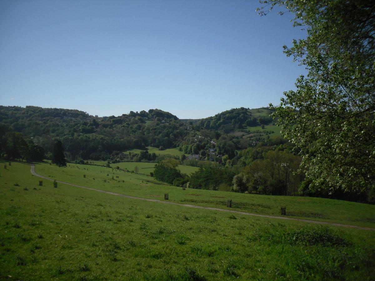
Beautiful Courtfield and the Wye.
Three-mile easy walk but with one short sharp climb towards the end.
Fine views and straight tracks on good terrain.
Map: OL14 Wye Valley and Forest of Dean.
The Route
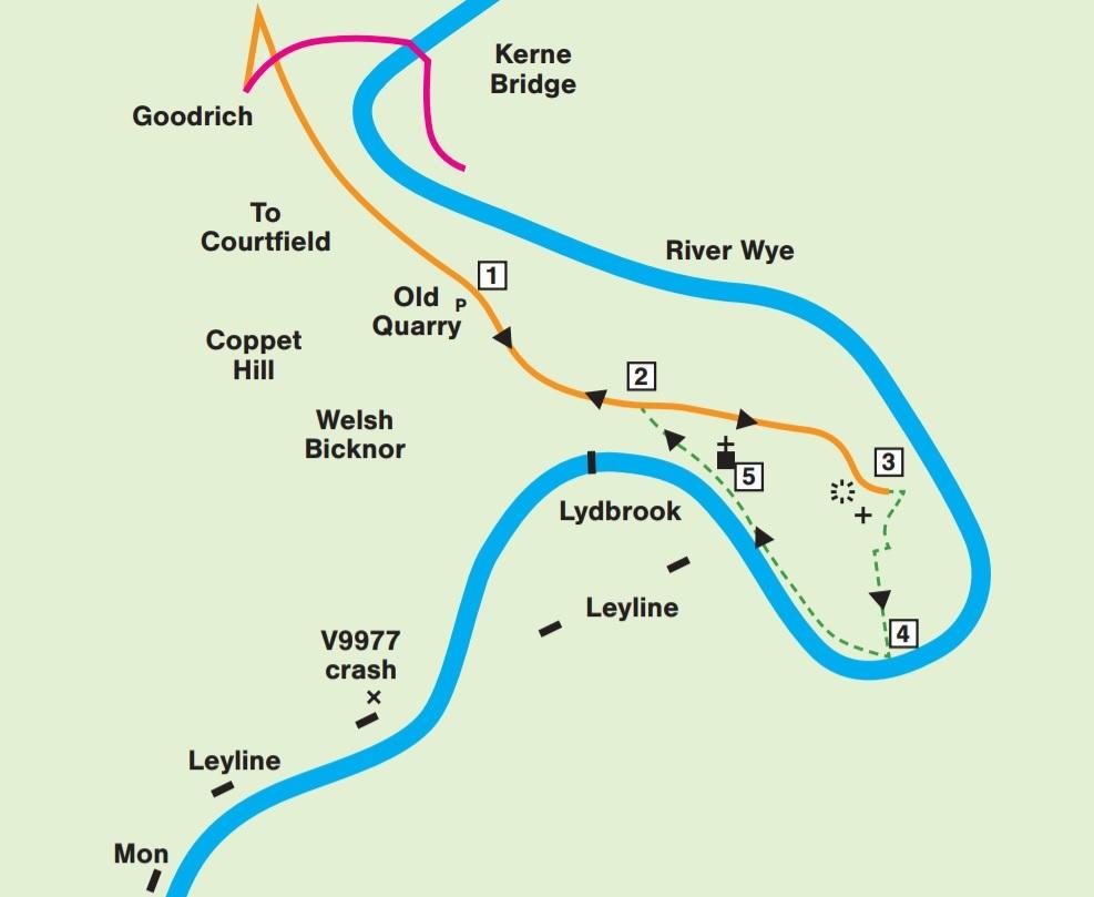
1. Old Quarry. Having left Goodrich, drive up the narrow road signed for Welsh Bicknor and Courtfield, for about ¾ mile. Find parking for about five or six vehicles on right in quite a gloomy old quarry (a footpath goes up to the right into Coppet Hill Nature Reserve.) Leave and walk up to right to cross cattle grid into Courtfield Estate. Now stay, strictly, on the lovely, fence-lined road surface for one third of a mile, curving left past Primrose Cottage, to
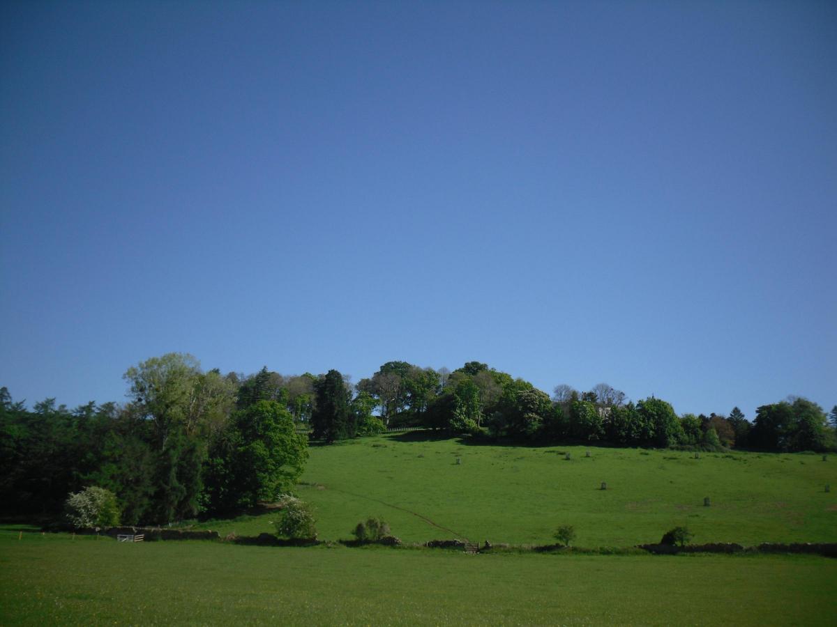
2. Fork in lanes. Take upper surfaced lane straight ahead, soon passing Courtfield Farm, with fine views opening out ahead south and east across the Courtfield Estate park and the River Wye. Carry on for half a mile, bear right, still on surfaced lane, to point below private mound with old structure up to right.
3. The Hermitage area. Strictly private. Stay on road. Site of ley lines inventor Alfred Watkins addressing the Woolhope Club in 1922. Turn left, still surfaced, as if for Home Fisheries and Thomas Wood. At telegraph pole go ahead through gate, down to fence corner. TR along the top edge, through gated gap, R edge of pasture and keep along R edge until you see a waymarked gate on R. Go through, down steps and turn immediately left. Follow this tree lined fence down to riverbank.
4. Turn right. Follow riverbank, along the Wye Valley Walk, three-fifths of a mile, passing three field divisions, to Welsh Bicknor church.
5. Pass below church, through lower park, leaving riverbank, below Youth Hostel, to find WVW information board. Proceed ahead for 35m to find public footpath going up through a strip of trees at east end of Park Wood. So, TR, steeply up through wood. At top, join lane, near a small parking bay and TL up to point 2. Continue ahead, back to quarry.


Comments: Our rules
We want our comments to be a lively and valuable part of our community - a place where readers can debate and engage with the most important local issues. The ability to comment on our stories is a privilege, not a right, however, and that privilege may be withdrawn if it is abused or misused.
Please report any comments that break our rules.
Read the rules here